from planetarypy import crs

crs.set_target_crs(crs.body_crs("mars"))
crs.get_target_crs().to_authority()
('IAU_2015', '49900')Making a footprint map legible with IAU nomenclature, in one coordinate frame
A footprint map answers “where is there data?”. It does not answer “data over what?” — for that you need the named geography. This walks through overlaying IAU-adopted feature names on real image footprints, and using a session-wide target CRS so the two layers are guaranteed to be in the same frame.
Requires the [geo] extra: pip install "planetarypy[geo]".
The problem this solves is mundane and easy to get wrong. Footprints arrive from one archive in one convention, feature names come from the USGS Gazetteer in another, and nothing stops you from plotting them on the same axes while they quietly disagree.
We work over Jezero Crater, Perseverance’s landing site.
Do this before fetching anything. Everything that follows converts into it, so there is no moment where two layers are in different systems.
from planetarypy import crs
crs.set_target_crs(crs.body_crs("mars"))
crs.get_target_crs().to_authority()('IAU_2015', '49900')body_crs("mars") resolves to the IAU_2015 sphere code for Mars (IAU_2015:49900, a == b) — the radii come from the IAU code itself, nothing is hardcoded.
Don’t type the coordinates. nomenclature.find returns the IAU record for a named feature, so the location is sourced rather than remembered.
from planetarypy import nomenclature

jezero = nomenclature.find("mars", "Jezero")
LON = jezero.center_lon.to_value("deg")
LAT = jezero.center_lat.to_value("deg")
LON, LAT, jezero.diameter
/Users/maye/Dropbox/Documents/01_projects/planetarypy/code/planetarypy/src/planetarypy/nomenclature.py:227: CRSConversionWarning: Reprojected mars nomenclature from ESRI:104905 to IAU_2015:49900 automatically. Pass an explicit CRS, or set planetarypy.crs.set_target_crs(...), to choose deliberately.
matches = features(body, name=name, **kwargs)(np.float64(77.68730000000001), np.float64(18.4082), <Quantity 47.5212 km>)The record carries the feature’s own extent too, and the numbers arrive as astropy quantities, so their units travel with them:
jezero[["min_lon", "max_lon", "min_lat", "max_lat", "diameter"]]min_lon 77.2663 deg
max_lon 78.11120000000001 deg
min_lat 18.0077 deg
max_lat 18.8094 deg
diameter 47.5212 km
Name: 0, dtype: objectSo the area of interest can be built from the feature rather than from a number someone guessed. We take Jezero’s own bounding box and pad it by a few crater diameters of context, converting km to degrees through the body’s own radius:
import numpy as np
from astropy import units as u

from planetarypy import constants

radius = constants.Mars.mean_radius            # a Quantity, in km
deg_per_length = (360 * u.deg) / (2 * np.pi * radius)

pad = (4 * jezero.diameter * deg_per_length).to(u.deg)
pad
\(3.2131498\mathrm{{}^{\circ}}\)
radius is in km. Had it been metres and this code assumed otherwise, the box would have come out 1000× too large — and nothing would have complained. Because both diameter and radius carry their units, the conversion either works or raises; it cannot quietly produce a wrong number.
Units are on by default. units.set_units(False), or with units.use_units(False):, hands back plain floats for code that wants them.
features takes plain degrees, so strip the unit at the boundary:
pad_deg = pad.to_value(u.deg)

BBOX = (jezero.min_lon.to_value(u.deg) - pad_deg,
        jezero.min_lat.to_value(u.deg) - pad_deg,
        jezero.max_lon.to_value(u.deg) + pad_deg,
        jezero.max_lat.to_value(u.deg) + pad_deg)
WEST_EAST = (BBOX[0], BBOX[2])
SOUTH_NORTH = (BBOX[1], BBOX[3])
BBOX
(np.float64(74.05315024174811),
np.float64(14.794550241748105),
np.float64(81.3243497582519),
np.float64(22.022549758251895))Nothing above is typed from memory: the location, the size and the body radius are all looked up.
nomenclature.features fetches the gazetteer for a body and caches it. Filters mirror how people actually narrow it: by feature class, by size, by area.
import textwrap
import warnings

from planetarypy.crs import CRSConversionWarning

with warnings.catch_warnings(record=True) as caught:
    warnings.simplefilter("always", CRSConversionWarning)
    near = nomenclature.features("mars", bbox=BBOX, min_diameter=3)

for w in caught:
    print(textwrap.fill(str(w.message), 78))
Reprojected mars nomenclature from ESRI:104905 to IAU_2015:49900
automatically. Pass an explicit CRS, or set
planetarypy.crs.set_target_crs(...), to choose deliberately.near[["name", "type", "diameter", "center_lon", "center_lat"]].head(8)| name | type | diameter | center_lon | center_lat | |
|---|---|---|---|---|---|
| 0 | Jezero | Crater, craters | 47.52120 | 77.6873 | 18.4082 |
| 1 | Hargraves | Crater, craters | 60.28112 | 75.7436 | 20.7371 |
| 2 | Nili Fossae | Fossa, fossae | 727.90630 | 76.6948 | 22.0182 |
| 3 | Angelica | Crater, craters | 3.50000 | 76.9500 | 18.6500 |
| 4 | Sedona | Crater, craters | 7.40000 | 77.5400 | 17.8400 |
| 5 | Una Vallis | Vallis, valles | 5.00000 | 77.0700 | 18.2900 |
| 6 | Neretva Vallis | Vallis, valles | 17.00000 | 77.2000 | 18.5500 |
| 7 | Nili Planum | Planum, plana | 128.54700 | 77.1000 | 18.6000 |
That call emitted a CRSConversionWarning. It is not noise — it is the whole point.
The gazetteer ships Mars as ESRI:104905 (GCS_Mars_2000, an ellipsoid). planetarypy standardises on IAU_2015. Those differ in more than their label, and a silent reprojection between them is exactly how two datasets end up subtly misaligned with nothing on screen to say so.
Because we set a session target CRS in step 1, the data arrived in the frame we asked for — and said so on the way.
near.crs.to_authority()('IAU_2015', '49900')Pass an explicit to_crs= and the warning goes away: you made the decision yourself, so there is nothing to tell you.
HRSC coverage over the same box, straight from ESA’s PSA.
from planetarypy import psa

hrsc = psa.query(
    "SELECT TOP 25 granule_uid, c1min, c1max, c2min, c2max "
    "FROM psa.epn_core "
    "WHERE instrument_host_name LIKE '%Mars Express%' "
    "  AND instrument_name LIKE '%HRSC%' "
    f"  AND c1min <= {WEST_EAST[1]} AND c1max >= {WEST_EAST[0]} "
    f"  AND c2min <= {SOUTH_NORTH[1]} AND c2max >= {SOUTH_NORTH[0]} "
    "  AND (c1max - c1min) < 30 AND (c2max - c2min) < 30"
)
len(hrsc)25< 30 clause
Orbital swaths crossing high latitudes get a degenerate bounding box spanning all longitudes. Without that filter you collect scenes that never imaged your area. See the cross-archive tutorial for the full set of PSA rough edges.
add_features is the coastlines() move: it draws onto axes you already have, and with bbox="auto" (the default) it reads their limits rather than making you restate the area.
import matplotlib.pyplot as plt
from matplotlib.patches import Rectangle

fig, ax = plt.subplots(figsize=(9, 8))

for row in hrsc:
    ax.add_patch(Rectangle(
        (row["c1min"], row["c2min"]),
        row["c1max"] - row["c1min"], row["c2max"] - row["c2min"],
        fill=False, ec="#1b9e77", lw=0.8, alpha=0.7, zorder=2,
    ))

ax.set_xlim(BBOX[0], BBOX[2])
ax.set_ylim(BBOX[1], BBOX[3])

drawn = nomenclature.add_features(ax, "mars", min_diameter=3)

ax.plot(LON, LAT, marker="*", ms=15, color="#7570b3", zorder=7)
ax.set_xlabel("east longitude (deg)")
ax.set_ylabel("planetocentric latitude (deg)")
ax.set_title("HRSC coverage over Jezero, with IAU nomenclature")
ax.grid(alpha=0.3, ls=":")
ax.set_aspect("equal")
plt.show();
/Users/maye/Dropbox/Documents/01_projects/planetarypy/code/planetarypy/src/planetarypy/nomenclature.py:344: CRSConversionWarning: Reprojected mars nomenclature from ESRI:104905 to IAU_2015:49900 automatically. Pass an explicit CRS, or set planetarypy.crs.set_target_crs(...), to choose deliberately.
gdf = features(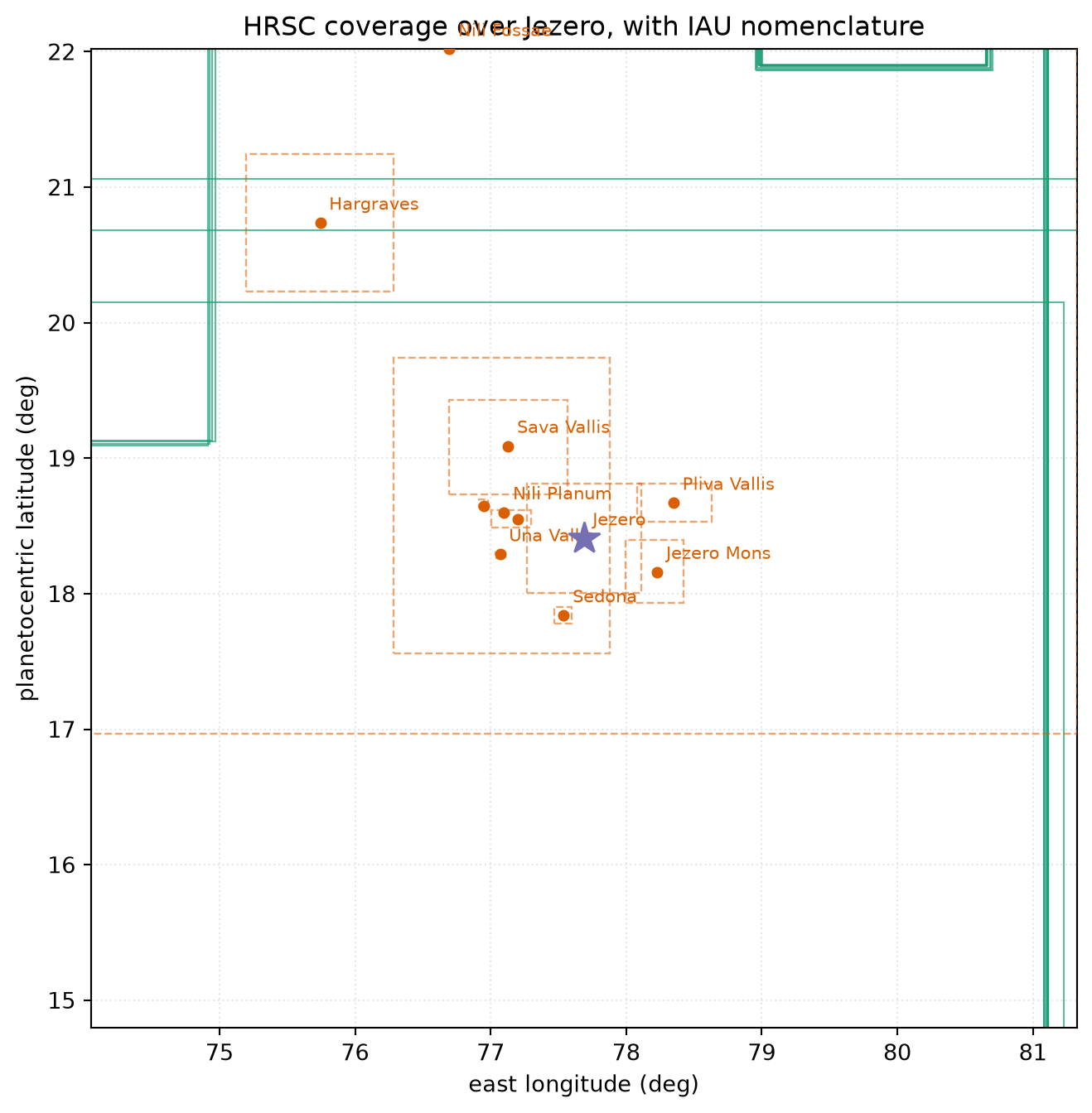
The dashed boxes are feature extents, drawn by default from the gazetteer’s min/max_lon and min/max_lat columns. This is the difference that matters: a centre point tells you a name is somewhere nearby, the box tells you whether a given footprint actually covers Jezero or merely passes near it. Pass extent=False for centre points only.
Labels are placed largest-feature-first and decluttered — a later label that would collide with one already placed is dropped rather than smeared over it.
drawn[["name", "diameter"]].sort_values("diameter", ascending=False).head(6)| name | diameter | |
|---|---|---|
| 2 | Nili Fossae | 727.90630 |
| 7 | Nili Planum | 128.54700 |
| 9 | Sava Vallis | 62.00000 |
| 1 | Hargraves | 60.28112 |
| 0 | Jezero | 47.52120 |
| 8 | Pliva Vallis | 30.00000 |
Distances are the usual reason. A geographic CRS measures in degrees, which are not a length; for “how far is this feature from the rover?” you want a local projection in metres. crs.target_crs swaps the frame for a block and puts it back afterwards.
local = crs.local_crs(LON, LAT, "mars")     # azimuthal equidistant on Jezero

with warnings.catch_warnings(record=True) as caught:
    warnings.simplefilter("always", CRSConversionWarning)
    with crs.target_crs(local):
        metric = nomenclature.features("mars", bbox=BBOX, min_diameter=3)
        print("inside the block:", metric.crs.to_authority() or metric.crs.name)

for w in caught:
    print(textwrap.fill(str(w.message), 78))

print("after the block:  ", crs.get_target_crs().to_authority())
inside the block: AzimuthalEquidistant(18.4082, 77.6873) on mars
Reprojected mars nomenclature from ESRI:104905 to
AzimuthalEquidistant(18.4082, 77.6873) on mars automatically. Pass an explicit
CRS, or set planetarypy.crs.set_target_crs(...), to choose deliberately.
after the block: ('IAU_2015', '49900')The session setting is restored on exit — and would be even if the block had raised. Now distances are real:
from shapely.geometry import Point

origin = Point(0, 0)   # the projection is centred on Jezero, so this is the site
metric["km_from_site"] = metric.geometry.distance(origin) / 1000
metric.nsmallest(6, "km_from_site")[["name", "km_from_site"]]| name | km_from_site | |
|---|---|---|
| 0 | Jezero | 0.000000 |
| 6 | Neretva Vallis | 28.655637 |
| 10 | Jezero Mons | 33.902695 |
| 4 | Sedona | 34.687030 |
| 7 | Nili Planum | 34.915039 |
| 5 | Una Vallis | 35.429514 |
crs.clear_target_crs()
crs.get_target_crs() is NoneTrueLeaving a session CRS set is harmless in a notebook, but a library function that sets one and never clears it would surprise its caller. Prefer the context manager where the scope is known.
planetarypy.nomenclature.bodies() lists all 47 bodies the gazetteer covers — the Moon has 9086 named features, Mercury 606, Europa 129.planetarypy.units toggles astropy units project-wide, with the same set/context-manager pair as the target CRS.