from planetarypy.pds import (
    print_available_indexes,
    get_mission_names,
    get_instrument_names,
    get_index_names,
    get_index,
)How to work with PDS Index files
In this tutorial, we will learn how to work with PDS Index files.
These files contain metadata about the observations and they were mostly provided for data that was delivered in the PDS3 format.
We first will look at the tree list of instrument data indexes that planetarypy is so far supporting.
Then we will have a look at several utility functions that help receiving the structures contained in this tree and finally the most important function get_index that retrieves the index file as a pandas DataFrame.
Working with PDS Index files
One of the major features of planetarypy is the ability to work with PDS Index files as part of its general agenda of helping users retrieving data of interest.
To this end, planetarypy provides a set of functions that allow you to work with PDS Index files:
Logging output.
If you want to know more about what is happening behind the scenes, use the next cell to activate various levels of logging details.
# planetarypy configures INFO level of logging by default but the user should switch it on:
from loguru import logger

logger.enable("planetarypy")

# To see all debug messages of planetarypy instead, use:
# import planetarypy
# planetarypy.enable_logging("DEBUG")

# To see only warnings and errors, use:
# planetarypy.enable_logging("WARNING")


# If you want to play with new code in here and want to log stuff, use a notebook-specific logger:
def create_nb_logger():
    import sys
    from loguru import logger

    nb_logger = logger.bind(context="notebook")
    nb_logger.add(
        sys.stdout,
        level="INFO",
        filter=lambda r: r["extra"].get("context") == "notebook",
    )


# Use nb_logger.info(), nb_logger.debug(), etc. for your notebook code
The overview
print_available_indexes() provides a tree-like overview of all instrument data indexes currently supported in planetarypy.
print_available_indexes()PDS Indexes Configuration:
├── cassini
│ ├── iss
│ │ ├── index
│ │ ├── inventory
│ │ ├── moon_summary
│ │ ├── ring_summary
│ │ └── saturn_summary
│ └── uvis
│ ├── index
│ ├── moon_summary
│ ├── ring_summary
│ ├── saturn_summary
│ ├── supplemental_index
│ └── versions
├── go
│ └── ssi
│ ├── body_summary
│ ├── index
│ ├── jupiter_summary
│ ├── moon_summary
│ ├── ring_summary
│ ├── sky_summary
│ └── supplemental_index
├── lro
│ ├── diviner
│ │ ├── edr1
│ │ ├── edr2
│ │ ├── rdr1
│ │ └── rdr2
│ ├── lola
│ │ ├── edr
│ │ └── rdr
│ └── lroc
│ └── edr
├── mer
│ ├── opportunity
│ │ └── pancam_rdr
│ └── spirit
│ └── pancam_rdr
└── mro
├── crism
│ └── mtrdr
├── ctx
│ └── edr
└── hirise
├── dtm
├── edr
└── rdrThe index keys are the strings that are used to directly and efficiently identify a given index file:
print_available_indexes(keys_only=True)['cassini.iss.index',
'cassini.iss.inventory',
'cassini.iss.moon_summary',
'cassini.iss.ring_summary',
'cassini.iss.saturn_summary',
'cassini.uvis.index',
'cassini.uvis.moon_summary',
'cassini.uvis.ring_summary',
'cassini.uvis.saturn_summary',
'cassini.uvis.supplemental_index',
'cassini.uvis.versions',
'go.ssi.body_summary',
'go.ssi.index',
'go.ssi.jupiter_summary',
'go.ssi.moon_summary',
'go.ssi.ring_summary',
'go.ssi.sky_summary',
'go.ssi.supplemental_index',
'lro.diviner.edr1',
'lro.diviner.edr2',
'lro.diviner.rdr1',
'lro.diviner.rdr2',
'lro.lola.edr',
'lro.lola.rdr',
'lro.lroc.edr',
'mer.opportunity.pancam_rdr',
'mer.spirit.pancam_rdr',
'mro.crism.mtrdr',
'mro.ctx.edr',
'mro.hirise.dtm',
'mro.hirise.edr',
'mro.hirise.rdr']Missions, instruments, indexes
The functions - get_mission_names(), - get_instrument_names(mission), and - get_index_names(<mission.instrument>)
allow you to retrieve Python lists of missions, instruments and indexes supported in planetarypy.
get_mission_names()['cassini', 'go', 'lro', 'mer', 'mro']Note that a listed mission does not necessarily mean that all existing index files for that mission are yet included in
planetarypy.
get_instrument_names("mro")['crism', 'ctx', 'hirise']get_index_names("mro.hirise")['dtm', 'edr', 'rdr']get_index("mro.hirise.rdr")| VOLUME_ID | FILE_NAME_SPECIFICATION | INSTRUMENT_HOST_ID | INSTRUMENT_ID | OBSERVATION_ID | PRODUCT_ID | PRODUCT_VERSION_ID | TARGET_NAME | ORBIT_NUMBER | MISSION_PHASE_NAME | ... | LINE_PROJECTION_OFFSET | SAMPLE_PROJECTION_OFFSET | CORNER1_LATITUDE | CORNER1_LONGITUDE | CORNER2_LATITUDE | CORNER2_LONGITUDE | CORNER3_LATITUDE | CORNER3_LONGITUDE | CORNER4_LATITUDE | CORNER4_LONGITUDE | |
|---|---|---|---|---|---|---|---|---|---|---|---|---|---|---|---|---|---|---|---|---|---|
| 0 | MROHR_0001 | RDR/AEB/ORB_000000_000099/AEB_000001_0150/AEB_... | MRO | HIRISE | AEB_000001_0150 | AEB_000001_0150_RED | 2 | MARS | 1 | Aerobraking | ... | -2070840.0 | -3104770.0 | -51.5351 | 300.528 | -51.6056 | 301.337 | -52.8767 | 301.004 | -52.8092 | 300.204 |
| 1 | MROHR_0001 | RDR/AEB/ORB_000000_000099/AEB_000001_0100/AEB_... | MRO | HIRISE | AEB_000001_0100 | AEB_000001_0100_RED | 2 | MARS | 1 | Aerobraking | ... | -1638060.0 | -2993950.0 | -47.0358 | 301.612 | -47.1137 | 302.451 | -47.2551 | 302.417 | -47.1778 | 301.579 |
| 2 | MROHR_0001 | RDR/AEB/ORB_000000_000099/AEB_000001_0050/AEB_... | MRO | HIRISE | AEB_000001_0050 | AEB_000001_0050_RED | 2 | MARS | 1 | Aerobraking | ... | -1173870.0 | -2731940.0 | -40.499 | 303.079 | -40.5927 | 303.983 | -40.7794 | 303.94 | -40.6864 | 303.039 |
| 3 | MROHR_0001 | RDR/AEB/ORB_000000_000099/AEB_000001_0000/AEB_... | MRO | HIRISE | AEB_000001_0000 | AEB_000001_0000_RED | 2 | MARS | 1 | Aerobraking | ... | -793892.0 | -2563790.0 | -33.3992 | 304.631 | -33.5174 | 305.639 | -33.9094 | 305.546 | -33.7933 | 304.545 |
| 4 | MROHR_0001 | RDR/AEB/ORB_000000_000099/AEB_000002_0150/AEB_... | MRO | HIRISE | AEB_000002_0150 | AEB_000002_0150_RED | 2 | MARS | 2 | Aerobraking | ... | -2565340.0 | 1055460.0 | -55.9649 | 140.253 | -56.0291 | 141.042 | -57.3947 | 140.643 | -57.3327 | 139.856 |
| ... | ... | ... | ... | ... | ... | ... | ... | ... | ... | ... | ... | ... | ... | ... | ... | ... | ... | ... | ... | ... | ... |
| 195531 | MROHR_0001 | RDR/ESP/ORB_089500_089599/ESP_089594_1785/ESP_... | MRO | HIRISE | ESP_089594_1785 | ESP_089594_1785_COLOR | 1 | MARS | 89594 | Extended Science Phase | ... | -333456.5 | -38392512.0 | -1.6143 | 341.971 | -1.6166 | 341.951 | -1.4067 | 341.926 | -1.4043 | 341.946 |
| 195532 | MROHR_0001 | RDR/ESP/ORB_089500_089599/ESP_089595_1810/ESP_... | MRO | HIRISE | ESP_089595_1810 | ESP_089595_1810_RED | 1 | MARS | 89595 | Extended Science Phase | ... | 118875.5 | -16018662.0 | 0.6841 | 315.243 | 0.6741 | 315.161 | 0.9927 | 315.122 | 1.0028 | 315.204 |
| 195533 | MROHR_0001 | RDR/ESP/ORB_089500_089599/ESP_089595_1810/ESP_... | MRO | HIRISE | ESP_089595_1810 | ESP_089595_1810_COLOR | 1 | MARS | 89595 | Extended Science Phase | ... | 118334.5 | -16021888.0 | 0.6798 | 315.207 | 0.6776 | 315.188 | 0.9962 | 315.149 | 0.9985 | 315.168 |
| 195534 | MROHR_0001 | RDR/ESP/ORB_089500_089599/ESP_089596_1705/ESP_... | MRO | HIRISE | ESP_089596_1705 | ESP_089596_1705_RED | 1 | MARS | 89596 | Extended Science Phase | ... | -2207955.5 | -25759390.0 | -9.5085 | 289.169 | -9.5183 | 289.087 | -9.3226 | 289.064 | -9.3128 | 289.146 |
| 195535 | MROHR_0001 | RDR/ESP/ORB_089500_089599/ESP_089596_1705/ESP_... | MRO | HIRISE | ESP_089596_1705 | ESP_089596_1705_COLOR | 1 | MARS | 89596 | Extended Science Phase | ... | -2209221.5 | -25765816.0 | -9.5129 | 289.133 | -9.5151 | 289.114 | -9.3195 | 289.091 | -9.3173 | 289.109 |
195536 rows × 54 columns
Common abbreviations used for PDS3 data types: - EDR: Experiment Data Record, usually the raw data - RDR: Reduced Data Record, usually the calibrated data
get_index("mer_opportunity.pancam.rdr")| VOLUME_ID | PATH_NAME | FILE_NAME | RELEASE_ID | PRODUCT_ID | PRODUCT_CREATION_TIME | TARGET_NAME | MISSION_PHASE_NAME | PLANET_DAY_NUMBER | START_TIME | ... | ERROR_PIXELS | FILTER_NAME | FILTER_NUMBER | FRAME_ID | FRAME_TYPE | AZIMUTH_FOV | ELEVATION_FOV | SOLAR_AZIMUTH | SOLAR_ELEVATION | SOLAR_LONGITUDE | |
|---|---|---|---|---|---|---|---|---|---|---|---|---|---|---|---|---|---|---|---|---|---|
| 0 | MER1PC_1002 | DATA/SOL0001/ | 1P128287181RAD0000P2303L2C1.IMG | 1.0 | 1P128287181RAD0000P2303L2C1 | 2016-06-27 19:41:06+00:00 | MARS | PRIMARY MISSION | 1 | 2004-01-25 07:18:28.781000+00:00 | ... | 71 | PANCAM_L2_753NM | 2 | LEFT | MONO | 15.8412 | 15.8412 | 260.595 | 36.7237 | 339.154 |
| 1 | MER1PC_1002 | DATA/SOL0001/ | 1P128287181RAT0000P2303L2C1.IMG | 1.0 | 1P128287181RAT0000P2303L2C1 | 2016-06-27 19:41:07+00:00 | MARS | PRIMARY MISSION | 1 | 2004-01-25 07:18:28.781000+00:00 | ... | 0 | PANCAM_L2_753NM | 2 | LEFT | MONO | 15.8412 | 15.8412 | 260.595 | 36.7237 | 339.154 |
| 2 | MER1PC_1002 | DATA/SOL0001/ | 1P128287214RAD0000P2303L5C1.IMG | 1.0 | 1P128287214RAD0000P2303L5C1 | 2016-06-27 19:41:07+00:00 | MARS | PRIMARY MISSION | 1 | 2004-01-25 07:19:01.280000+00:00 | ... | 0 | PANCAM_L5_535NM | 5 | LEFT | MONO | 15.8412 | 15.8412 | 260.606 | 36.5937 | 339.154 |
| 3 | MER1PC_1002 | DATA/SOL0001/ | 1P128287214RAT0000P2303L5C1.IMG | 1.0 | 1P128287214RAT0000P2303L5C1 | 2016-06-27 19:41:08+00:00 | MARS | PRIMARY MISSION | 1 | 2004-01-25 07:19:01.280000+00:00 | ... | 0 | PANCAM_L5_535NM | 5 | LEFT | MONO | 15.8412 | 15.8412 | 260.606 | 36.5937 | 339.154 |
| 4 | MER1PC_1002 | DATA/SOL0001/ | 1P128287236RAD0000P2303L6C1.IMG | 1.0 | 1P128287236RAD0000P2303L6C1 | 2016-06-27 19:41:09+00:00 | MARS | PRIMARY MISSION | 1 | 2004-01-25 07:19:23.905000+00:00 | ... | 0 | PANCAM_L6_483NM | 6 | LEFT | MONO | 15.8412 | 15.8412 | 260.614 | 36.5033 | 339.154 |
| ... | ... | ... | ... | ... | ... | ... | ... | ... | ... | ... | ... | ... | ... | ... | ... | ... | ... | ... | ... | ... | ... |
| 327595 | MER1PC_1002 | DATA/SOL5111/ | 1P581919922RATD2FCP2682R8A1.IMG | 58.0 | 1P581919922RATD2FCP2682R8A1 | 2019-05-07 01:37:46+00:00 | MARS | EXTENDED MISSION | 5111 | 2018-06-10 16:28:09.915000+00:00 | ... | 0 | PANCAM_R8_880NM_SOL_ND5 | 8 | RIGHT | STEREO | 15.8412 | 15.8412 | 265.224 | 48.889 | 190.919 |
| 327596 | MER1PC_1002 | DATA/SOL5111/ | 1P581919984RATD2FCP2682L8A1.IMG | 58.0 | 1P581919984RATD2FCP2682L8A1 | 2019-05-07 01:37:46+00:00 | MARS | EXTENDED MISSION | 5111 | 2018-06-10 16:29:11.540000+00:00 | ... | 0 | PANCAM_L8_440NM_SOL_ND5 | 8 | LEFT | STEREO | 15.8412 | 15.8412 | 265.239 | 48.6401 | 190.92 |
| 327597 | MER1PC_1002 | DATA/SOL5111/ | 1P581919984RATD2FCP2682R8A1.IMG | 58.0 | 1P581919984RATD2FCP2682R8A1 | 2019-05-07 01:37:47+00:00 | MARS | EXTENDED MISSION | 5111 | 2018-06-10 16:29:11.540000+00:00 | ... | 0 | PANCAM_R8_880NM_SOL_ND5 | 8 | RIGHT | STEREO | 15.8412 | 15.8412 | 265.239 | 48.6401 | 190.92 |
| 327598 | MER1PC_1002 | DATA/SOL5111/ | 1P581920080RATD2FCP2682L7A1.IMG | 58.0 | 1P581920080RATD2FCP2682L7A1 | 2019-05-07 01:37:47+00:00 | MARS | EXTENDED MISSION | 5111 | 2018-06-10 16:30:47.665000+00:00 | ... | 0 | PANCAM_L7_440NM | 7 | LEFT | STEREO | 15.8412 | 15.8412 | 265.261 | 48.2518 | 190.92 |
| 327599 | MER1PC_1002 | DATA/SOL5111/ | 1P581920080RATD2FCP2682R2A1.IMG | 58.0 | 1P581920080RATD2FCP2682R2A1 | 2019-05-07 01:37:48+00:00 | MARS | EXTENDED MISSION | 5111 | 2018-06-10 16:30:47.665000+00:00 | ... | 0 | PANCAM_R2_754NM | 2 | RIGHT | STEREO | 15.8412 | 15.8412 | 265.261 | 48.2518 | 190.92 |
327600 rows × 34 columns
Dotted index names
The names of the indexes are dotted names, where the first part is the mission, then the instrument name, and finally the name of the index file, which can be retrieved using the list_indexs() function.
Retrieving the index as a pandas DataFrame
The first time the index is requested, it will - downloaded the label and table file belonging to an index, - import it into a pandas.DataFrame, - convert the time strings to datetime objects and - store it as a parquet file on the disk.
The get_index function shown below will then return the DataFrame to the user.
The next time the index is being requested, it will be read from the parquet file on the disk, if no newer file is available on the PDS server, otherwise the updated index will be acquired.
df = get_index("mro.ctx.edr")
df.head() # print the first few rows of the index| VOLUME_ID | FILE_SPECIFICATION_NAME | ORIGINAL_PRODUCT_ID | PRODUCT_ID | IMAGE_TIME | INSTRUMENT_ID | INSTRUMENT_MODE_ID | LINE_SAMPLES | LINES | SPATIAL_SUMMING | ... | SUB_SOLAR_LATITUDE | SUB_SPACECRAFT_LONGITUDE | SUB_SPACECRAFT_LATITUDE | SOLAR_DISTANCE | SOLAR_LONGITUDE | LOCAL_TIME | IMAGE_SKEW_ANGLE | RATIONALE_DESC | DATA_QUALITY_DESC | ORBIT_NUMBER | |
|---|---|---|---|---|---|---|---|---|---|---|---|---|---|---|---|---|---|---|---|---|---|
| 0 | MROX_0001 | DATA/CRU_000001_9999_XN_99N999W.IMG | 4A_04_0001000400 | CRU_000001_9999_XN_99N999W | 2005-08-30 15:40:21.549 | CTX | NIFL | 5056 | 1024 | 1 | ... | 0.0 | 0.0 | 0.0 | 0.0 | 278.89 | 10.16 | 0.0 | Instrument checkout image of space | OK | -4242 |
| 1 | MROX_0001 | DATA/CRU_000002_9999_XN_99N999W.IMG | 4A_04_0001000500 | CRU_000002_9999_XN_99N999W | 2005-09-08 15:59:45.313 | CTX | NIFL | 5056 | 15360 | 1 | ... | 0.0 | 0.0 | 0.0 | 0.0 | 284.48 | 4.6 | 0.0 | Calibration image of the Moon | OK | -4126 |
| 2 | MROX_0001 | DATA/CRU_000003_9999_XN_99N999W.IMG | 4A_04_0001000600 | CRU_000003_9999_XN_99N999W | 2005-09-08 16:03:37.927 | CTX | NIFL | 5056 | 2048 | 1 | ... | 0.0 | 0.0 | 0.0 | 0.0 | 284.48 | 4.66 | 0.0 | Calibration image of Omega Centauri (globular ... | OK | -4126 |
| 3 | MROX_0001 | DATA/CRU_000004_9999_XN_99N999W.IMG | 4A_04_0001000700 | CRU_000004_9999_XN_99N999W | 2005-09-08 16:08:23.841 | CTX | NIFL | 5056 | 2048 | 1 | ... | 0.0 | 0.0 | 0.0 | 0.0 | 284.48 | 4.74 | 0.0 | Calibration image of Omega Centauri (globular ... | OK | -4126 |
| 4 | MROX_0001 | DATA/CRU_000005_9999_XN_99N999W.IMG | 4A_04_0001000800 | CRU_000005_9999_XN_99N999W | 2005-09-08 16:11:18.649 | CTX | NIFL | 5056 | 21504 | 1 | ... | 0.0 | 0.0 | 0.0 | 0.0 | 284.48 | 4.79 | 0.0 | Calibration image of the Moon | OK | -4126 |
5 rows × 51 columns
Specialized metadata
The Cassini indexes have some specialized metadata that is not available in the other indexes, thanks to extra work done by the PDS Rings-Moons node team.
Let’s have a look what kind of data is available in the different indexes, using the ISS camera as an example.
get_index_names("cassini.iss")['index', 'inventory', 'moon_summary', 'ring_summary', 'saturn_summary']index = get_index("cassini.iss.index")
index.head()2026-01-27 19:00:41 | WARNING | planetarypy.pds.static_index:get_remote_timestamp - Could not retrieve remote timestamp for https://pds-rings.seti.org/holdings/metadata/COISS_2xxx/COISS_2999/COISS_2999_index.lbl: HTTP Error 403: Forbidden
| FILE_NAME | FILE_SPECIFICATION_NAME | VOLUME_ID | ANTIBLOOMING_STATE_FLAG | BIAS_STRIP_MEAN | CALIBRATION_LAMP_STATE_FLAG | COMMAND_FILE_NAME | COMMAND_SEQUENCE_NUMBER | DARK_STRIP_MEAN | DATA_CONVERSION_TYPE | ... | TWIST_ANGLE | TARGET_LIST | UPPER_LEFT_LATITUDE | UPPER_LEFT_LONGITUDE | UPPER_RIGHT_LATITUDE | UPPER_RIGHT_LONGITUDE | DATA_SET_NAME | INSTRUMENT_HOST_ID | PRODUCT_TYPE | STANDARD_DATA_PRODUCT_ID | |
|---|---|---|---|---|---|---|---|---|---|---|---|---|---|---|---|---|---|---|---|---|---|
| 0 | N1454725799_1.IMG | data/1454725799_1455008789/N1454725799_1.IMG | COISS_2001 | OFF | 14.869863 | N/A | OPNAV_848_3.ioi | 8 | 0.0 | 12BIT | ... | 89.513591 | S2_2004,HELENE,TELESTO,RHEA | -100000000000000005366162204393472.0 | -100000000000000005366162204393472.0 | -100000000000000005366162204393472.0 | -100000000000000005366162204393472.0 | CASSINI ORBITER SATURN ISSNA/ISSWA 2 EDR VERSI... | CO | EDR | ISS_EDR |
| 1 | N1454726579_1.IMG | data/1454725799_1455008789/N1454726579_1.IMG | COISS_2001 | OFF | 14.860078 | N/A | OPNAV_864_3.ioi | 8 | 0.0 | 12BIT | ... | 89.647635 | TITAN | -100000000000000005366162204393472.0 | -100000000000000005366162204393472.0 | -100000000000000005366162204393472.0 | -100000000000000005366162204393472.0 | CASSINI ORBITER SATURN ISSNA/ISSWA 2 EDR VERSI... | CO | EDR | ISS_EDR |
| 2 | N1454727359_1.IMG | data/1454725799_1455008789/N1454727359_1.IMG | COISS_2001 | OFF | 14.87867 | N/A | OPNAV_880_3.ioi | 8 | 0.0 | 12BIT | ... | 89.679084 | HYPERION | -100000000000000005366162204393472.0 | -100000000000000005366162204393472.0 | -100000000000000005366162204393472.0 | -100000000000000005366162204393472.0 | CASSINI ORBITER SATURN ISSNA/ISSWA 2 EDR VERSI... | CO | EDR | ISS_EDR |
| 3 | N1454728139_1.IMG | data/1454725799_1455008789/N1454728139_1.IMG | COISS_2001 | OFF | 14.842465 | N/A | OPNAV_912_3.ioi | 8 | 0.0 | 12BIT | ... | 88.677516 | PHOEBE | -100000000000000005366162204393472.0 | -100000000000000005366162204393472.0 | -100000000000000005366162204393472.0 | -100000000000000005366162204393472.0 | CASSINI ORBITER SATURN ISSNA/ISSWA 2 EDR VERSI... | CO | EDR | ISS_EDR |
| 4 | N1454728919_1.IMG | data/1454725799_1455008789/N1454728919_1.IMG | COISS_2001 | OFF | 14.86497 | N/A | OPNAV_896_3.ioi | 8 | 0.0 | 12BIT | ... | 89.79891 | IAPETUS | -100000000000000005366162204393472.0 | -100000000000000005366162204393472.0 | -100000000000000005366162204393472.0 | -100000000000000005366162204393472.0 | CASSINI ORBITER SATURN ISSNA/ISSWA 2 EDR VERSI... | CO | EDR | ISS_EDR |
5 rows × 140 columns
moons = get_index("cassini.iss.moon_summary")2026-01-27 19:00:44 | WARNING | planetarypy.pds.static_index:get_remote_timestamp - Could not retrieve remote timestamp for https://pds-rings.seti.org/holdings/metadata/COISS_2xxx/COISS_2999/COISS_2999_moon_summary.lbl: HTTP Error 403: Forbidden
moons.head()| VOLUME_ID | FILE_SPECIFICATION_NAME | OPUS_ID | TARGET_NAME | MINIMUM_PLANETOCENTRIC_LATITUDE | MAXIMUM_PLANETOCENTRIC_LATITUDE | MINIMUM_PLANETOGRAPHIC_LATITUDE | MAXIMUM_PLANETOGRAPHIC_LATITUDE | MINIMUM_IAU_LONGITUDE | MAXIMUM_IAU_LONGITUDE | ... | MAXIMUM_EMISSION_ANGLE | SUB_SOLAR_PLANETOCENTRIC_LATITUDE | SUB_SOLAR_PLANETOGRAPHIC_LATITUDE | SUB_OBSERVER_PLANETOCENTRIC_LATITUDE | SUB_OBSERVER_PLANETOGRAPHIC_LATITUDE | SUB_SOLAR_IAU_LONGITUDE | SUB_OBSERVER_IAU_LONGITUDE | CENTER_RESOLUTION | CENTER_DISTANCE | CENTER_PHASE_ANGLE | |
|---|---|---|---|---|---|---|---|---|---|---|---|---|---|---|---|---|---|---|---|---|---|
| 0 | COISS_2001 | data/1454725799_1455008789/N1454725799_1.LBL | co-iss-n1454725799 | RHEA | -999.0 | -999.0 | -999.0 | -999.0 | -999.0 | -999.0 | ... | -999.0 | -25.206 | -25.442 | -16.566 | -16.558 | 183.907 | 252.947 | 423.6356 | 70701354.366 | 64.429 |
| 1 | COISS_2001 | data/1454725799_1455008789/N1454725799_1.LBL | co-iss-n1454725799 | HELENE | -999.0 | -999.0 | -999.0 | -999.0 | -999.0 | -999.0 | ... | -999.0 | -25.532 | -50.716 | -16.532 | -36.57 | 148.17 | 217.149 | 424.36902 | 70823757.002 | 64.345 |
| 2 | COISS_2001 | data/1454725799_1455008789/N1454725799_1.LBL | co-iss-n1454725799 | TELESTO | -999.0 | -999.0 | -999.0 | -999.0 | -999.0 | -999.0 | ... | -999.0 | -26.061 | -51.51 | -15.639 | -21.616 | 189.199 | 257.807 | 424.28746 | 70810144.519 | 64.28 |
| 3 | COISS_2001 | data/1454725799_1455008789/N1454726579_1.LBL | co-iss-n1454726579 | TITAN | -36.111 | -36.111 | -36.111 | -36.111 | 0.0 | 360.0 | ... | 54.704 | -25.325 | -25.325 | -16.28 | -16.28 | 340.092 | 47.855 | 428.89673 | 71579395.066 | 63.37 |
| 4 | COISS_2001 | data/1454725799_1455008789/N1454727359_1.LBL | co-iss-n1454727359 | HYPERION | -999.0 | -999.0 | -999.0 | -999.0 | -999.0 | -999.0 | ... | -999.0 | 11.777 | 25.907 | 44.104 | 57.544 | 173.985 | 237.769 | 418.94545 | 69918606.586 | 63.093 |
5 rows × 35 columns
moons.columns.valuesarray(['VOLUME_ID', 'FILE_SPECIFICATION_NAME', 'OPUS_ID', 'TARGET_NAME',
'MINIMUM_PLANETOCENTRIC_LATITUDE',
'MAXIMUM_PLANETOCENTRIC_LATITUDE',
'MINIMUM_PLANETOGRAPHIC_LATITUDE',
'MAXIMUM_PLANETOGRAPHIC_LATITUDE', 'MINIMUM_IAU_LONGITUDE',
'MAXIMUM_IAU_LONGITUDE', 'MINIMUM_LOCAL_HOUR_ANGLE',
'MAXIMUM_LOCAL_HOUR_ANGLE', 'MINIMUM_LONGITUDE_WRT_OBSERVER',
'MAXIMUM_LONGITUDE_WRT_OBSERVER',
'MINIMUM_FINEST_SURFACE_RESOLUTION',
'MAXIMUM_FINEST_SURFACE_RESOLUTION',
'MINIMUM_COARSEST_SURFACE_RESOLUTION',
'MAXIMUM_COARSEST_SURFACE_RESOLUTION', 'MINIMUM_SURFACE_DISTANCE',
'MAXIMUM_SURFACE_DISTANCE', 'MINIMUM_PHASE_ANGLE',
'MAXIMUM_PHASE_ANGLE', 'MINIMUM_INCIDENCE_ANGLE',
'MAXIMUM_INCIDENCE_ANGLE', 'MINIMUM_EMISSION_ANGLE',
'MAXIMUM_EMISSION_ANGLE', 'SUB_SOLAR_PLANETOCENTRIC_LATITUDE',
'SUB_SOLAR_PLANETOGRAPHIC_LATITUDE',
'SUB_OBSERVER_PLANETOCENTRIC_LATITUDE',
'SUB_OBSERVER_PLANETOGRAPHIC_LATITUDE', 'SUB_SOLAR_IAU_LONGITUDE',
'SUB_OBSERVER_IAU_LONGITUDE', 'CENTER_RESOLUTION',
'CENTER_DISTANCE', 'CENTER_PHASE_ANGLE'], dtype=object)Let’s have a look which columns are common between these different indexes.
# Get common columns using set intersection
common_columns = set(index.columns).intersection(set(moons.columns))
print("Common columns between df and moons:")
for col in sorted(common_columns):
    print(f"- {col}")
Common columns between df and moons:
- FILE_SPECIFICATION_NAME
- TARGET_NAME
- VOLUME_IDindex.FILE_SPECIFICATION_NAME.head()0 data/1454725799_1455008789/N1454725799_1.IMG
1 data/1454725799_1455008789/N1454726579_1.IMG
2 data/1454725799_1455008789/N1454727359_1.IMG
3 data/1454725799_1455008789/N1454728139_1.IMG
4 data/1454725799_1455008789/N1454728919_1.IMG
Name: FILE_SPECIFICATION_NAME, dtype: stringmoons.FILE_SPECIFICATION_NAME.head()0 data/1454725799_1455008789/N1454725799_1.LBL
1 data/1454725799_1455008789/N1454725799_1.LBL
2 data/1454725799_1455008789/N1454725799_1.LBL
3 data/1454725799_1455008789/N1454726579_1.LBL
4 data/1454725799_1455008789/N1454727359_1.LBL
Name: FILE_SPECIFICATION_NAME, dtype: stringStats with index files
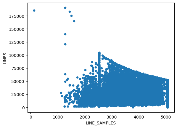
Index files can serve as a good means to get to know to a dataset. Here we look at the stats for the image sizes available. Instead of rows and columns in the PDS lingo they are called LINES and LINE_SAMPLES.
ctx = get_index("mro.ctx.edr")import hvplot.pandas # this enables automatic dynamic plots for pandas DataFramesctx.columnsIndex(['VOLUME_ID', 'FILE_SPECIFICATION_NAME', 'ORIGINAL_PRODUCT_ID',
'PRODUCT_ID', 'IMAGE_TIME', 'INSTRUMENT_ID', 'INSTRUMENT_MODE_ID',
'LINE_SAMPLES', 'LINES', 'SPATIAL_SUMMING', 'SCALED_PIXEL_WIDTH',
'PIXEL_ASPECT_RATIO', 'EMISSION_ANGLE', 'INCIDENCE_ANGLE',
'PHASE_ANGLE', 'CENTER_LONGITUDE', 'CENTER_LATITUDE',
'UPPER_LEFT_LONGITUDE', 'UPPER_LEFT_LATITUDE', 'UPPER_RIGHT_LONGITUDE',
'UPPER_RIGHT_LATITUDE', 'LOWER_LEFT_LONGITUDE', 'LOWER_LEFT_LATITUDE',
'LOWER_RIGHT_LONGITUDE', 'LOWER_RIGHT_LATITUDE', 'MISSION_PHASE_NAME',
'TARGET_NAME', 'SPACECRAFT_CLOCK_START_COUNT',
'FOCAL_PLANE_TEMPERATURE', 'LINE_EXPOSURE_DURATION', 'OFFSET_MODE_ID',
'SAMPLE_FIRST_PIXEL', 'SCALED_IMAGE_WIDTH', 'SCALED_IMAGE_HEIGHT',
'SPACECRAFT_ALTITUDE', 'TARGET_CENTER_DISTANCE', 'SLANT_DISTANCE',
'USAGE_NOTE', 'NORTH_AZIMUTH', 'SUB_SOLAR_AZIMUTH',
'SUB_SOLAR_LONGITUDE', 'SUB_SOLAR_LATITUDE', 'SUB_SPACECRAFT_LONGITUDE',
'SUB_SPACECRAFT_LATITUDE', 'SOLAR_DISTANCE', 'SOLAR_LONGITUDE',
'LOCAL_TIME', 'IMAGE_SKEW_ANGLE', 'RATIONALE_DESC', 'DATA_QUALITY_DESC',
'ORBIT_NUMBER'],
dtype='object')ctx.hvplot.scatter(x="LINE_SAMPLES", y="LINES")# use the matplotlib plots if hvplot is not available
ctx.plot.scatter(x="LINE_SAMPLES", y="LINES")